Alamut stands among the most mysterious fortresses of our land—a rugged refuge that, due to its challenging terrain, provided a secure shelter for many warriors. Among its notable inhabitants were the Ismailis, followers of Hassan-i Sabbah, who took refuge in these towering fortresses for centuries, resisting their foes with unwavering determination. The legacy they left behind in Alamut is truly astonishing. A brief overview of its unique features, geographical setting, and the neighboring fortresses reveals more about these marvels.
The Alamut Valley is a mountainous region located in the heart of the Alborz Mountain range, currently part of Qazvin Province. Historically, it was sometimes considered part of Deilaman, a region between Gilan and Mazandaran along the Caspian Sea coast. The Alamut area extends from the northwest (Gilan) to the southwest.
The high elevations flanking the valley created a natural fortress, making access to the mountain peaks extremely difficult. With numerous castles built atop these heights, Alamut became a nearly impregnable and hard-to-reach stronghold. In total, approximately 60 fortresses, watchtowers, and major Ismaili castles were constructed throughout the Alamut Valley. Among them, seven fortresses appear to have formed a connected network. These seven are known as Alamut, Lambsar, Shirkuh, Shams Kelayeh, Navizar Shah, Qostin Lar, and Ilan. Archaeologists refer to this cluster as the “Defensive Landscape of Alamut.”
The Alamut fortress is situated northeast of the village of Gazorkhan, perched atop a mountain rising 2,100 meters above sea level. The striking red and gray colors of the mountain make the fortress’s appearance unique. From every angle, the fortress is surrounded by daunting cliffs that give it an air of mystery and seclusion. The only accessible entrance lies to the northeast, beneath the shadow of Mount Hoodkan.
Locals refer to the Alamut fortress as “Qaleh Hasan” (Hasan’s Castle), named after Hassan-i Sabbah, the leader of the Ismaili sect in Iran. He and his followers expanded the fortress, transforming it into an impregnable stronghold. The fortress itself is divided into two parts: the higher western section called “Jorqela,” meaning “Upper Castle,” and the eastern section known as “Jirqela,” or “Lower Castle.” Together, these two sections stretch about 120 meters in length and up to 35 meters in width.
To the northwest of Gazorkhan village, atop a solid stone mountain, lies a steep cliff—an imposing natural barrier. The famed Alamut fortress was constructed there during the early 3rd century AH by the Zaydi rulers of Gilan and Mazandaran. Later, in 483 AH, Hassan-i Sabbah and his followers seized the fortress, naming it Alamut—or it came to be known by this name.
The name “Alamut” is often interpreted as eagle’s nest, with “Ala” meaning eagle and “mut” meaning nest. Others trace “Amut” to the Tati language—a northeastern Iranian tongue—where it means “tamed” or “trained,” suggesting the meaning “tamed eagle.” There are, however, various other interpretations of this less familiar term.
As previously noted, the only entrance to Alamut fortress lies on its northeastern side. There, a tunnel measuring 6 meters long, 2 meters wide, and 2 meters high was carved out, serving as the sole passageway into the fortress. The structure itself is built upon a steep rocky incline.
On the southern slope of the fortress, a moat was dug, extending 50 meters in length and 2 meters in width. During the fortress’s prime, this moat was filled with water to further deter enemies and outsiders from gaining access. Other moats are also visible along the high cliff walls, all designed as defensive barriers. Wherever natural crevices existed, stone or brick walls were constructed to make reaching Alamut even more difficult.
The central part of the fortress is known as “Hasan Sabbah’s Seat.” Hasan Sabbah lived here for 35 years, leading his Ismaili followers from this command center. The collapsed arches of his seat can still be seen today. It is important to note that the Mongols set fire to and destroyed this part of the fortress in the 7th century AH.
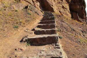
The Alamut fortress and its surrounding castles have witnessed a tumultuous history, but their most remarkable period dates back to the era when Hassan-i Sabbah and his successors governed them—spanning nearly 160 years. During this time, they expanded the fortresses, extending the area to about 20,000 square meters. Today, stone steps have been constructed at the fortress’s entrance to facilitate easier access.
In 2002 (1381 in the Iranian calendar), Alamut fortress was officially registered on Iran’s National Heritage List. We now await its designation as a UNESCO World Heritage site, which is expected to happen in the near future.