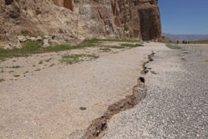
Land subsidence, which currently affects over 800 cities—including 16 major metropolitan areas—has now reached dangerously close to the ancient site of Naqsh-e Rustam, at a distance of just 10 meters, and between 300 to 500 meters from Persepolis (Takht-e Jamshid). Experts warn that subsidence in Tehran could potentially activate active fault lines in the region.
According to ISNA, the Research Institute for Cultural Heritage and Tourism announced during a specialized seminar on climate change and cultural heritage that it is compiling an atlas documenting subsidence impacts on Iran’s archaeological sites.
The seminar, chaired by Aminollah Kamali and held at the Research Institute, featured Professor Mehdi Zare’ from the International Institute of Earthquake Engineering and Seismology. He voiced serious concerns over the growing problem of land subsidence across the country, noting that this issue not only threatens Iran’s valuable cultural heritage but may also contribute to triggering active fault lines.
Professor Zare’ explained that near Naqsh-e Rustam, extensive agriculture and livestock farming—particularly ongoing rice and corn cultivation—have led to excessive groundwater extraction. This overexploitation has caused significant subsidence, with large cracks now visible just 10 meters from Naqsh-e Rustam and 300 to 500 meters from Persepolis.
Professor Zare’ pointed to the critical situation in Marvdasht, Fars Province, noting that near the ancient site of Naqsh-e Rustam—the resting place of Achaemenid kings and the Zoroastrian Kaaba—intensive agriculture and livestock farming, particularly the ongoing cultivation of rice and corn, have led to extensive groundwater extraction. This overuse has caused land subsidence visible as large cracks, occurring as close as 10 meters from Naqsh-e Rustam and between 300 to 500 meters from Persepolis (Takht-e Jamshid).
He added that subsidence in the Marvdasht plain has reached rates of 20 to 30 centimeters per year in recent years. This trend persists despite groundwater withdrawal exceeding the natural replenishment of the aquifer.
Regarding Tehran, Professor Zare’ highlighted dangerous subsidence in various areas, including Andisheh town, where the ground level has reportedly dropped by as much as 12 meters over the last four decades. Although this subsidence happens gradually and may go unnoticed by residents, it poses serious threats to infrastructure and could impact active fault lines in the region.
He stressed that land subsidence in Tehran Province could potentially trigger active faults. The evidence suggests that the severity of subsidence here may influence seismic activity along these faults.
Professor Zare’ called for immediate action to regulate excessive groundwater extraction and urged a reassessment of agricultural practices as crucial steps to mitigate the subsidence crisis and prevent further damage.
Land Subsidence Impacts 800 Cities and 16 Major Urban Centers
Masoumeh Amigh-Pay, head of the Precision Leveling and Radar Interferometry Department at the National Cartography Organization, warned about the alarming state of land subsidence in Iran, calling it a serious threat to the nation’s archaeological sites, food security, and natural resources.
She reported that over 800 cities and 16 large metropolitan areas are located within subsidence-prone regions, with 30 provinces affected to varying degrees. The main factors driving this crisis include excessive groundwater extraction, climate change, and ongoing droughts.
Amigh-Pay stressed that land subsidence decreases soil porosity, leading to rapid degradation of agricultural lands. For instance, significant parts of the Varamin plain have become uncultivable. Additional impacts include groundwater salinization, the formation of sinkholes, and surface cracks, which may increase the risk of severe flooding.
To address these issues, the National Cartography Organization has developed detailed subsidence atlases for different regions of the country.
The cultural heritage researcher explained that these atlases, created using radar interferometry data and precise leveling techniques, identify high-risk areas and provide essential information for effective crisis management.
Amigh-Pay also emphasized the importance of collaboration among relevant organizations to protect the country’s cultural heritage. She proposed the development of a comprehensive subsidence atlas covering both national and global archaeological sites to identify threatened locations and implement necessary protective measures.
She added that they are ready to cooperate with the Cultural Heritage Research Institute and highlighted the need to establish triple-buffer zones to safeguard archaeological sites.
The head of the Precision Leveling and Radar Interferometry Department at the National Cartography Organization called for scientific and sustainable water resource management, changes in cropping patterns, and an end to excessive groundwater extraction to prevent the worsening of the subsidence crisis and its associated threats.
The Necessity of a Comprehensive and Interdisciplinary Approach to Cultural Heritage Preservation
Khabat Derfashi, assistant professor of the Natural Heritage Department at Iran’s Cultural Heritage and Tourism Research Institute, addressed the connection between cultural heritage, the environment, and natural hazards in this meeting.
He explained that cultural heritage is not limited to historical monuments but also includes natural ecosystems and the interaction between humans and nature. Derfashi noted that natural processes, such as volcanic eruptions or droughts, can become natural hazards when they intersect with human systems, often exceeding the resilience capacity of human communities.
He emphasized the importance of preventive measures, effective crisis management, public awareness, good governance, and analyzing key factors like water extraction using precise measurement tools to safeguard both natural and cultural heritage.
Derfashi highlighted that environmental threats affect not only natural heritage but also have broader cultural and social impacts.
He stressed the need for a holistic and interdisciplinary approach to protecting cultural and natural heritage, involving natural resource management, urban planning, and the active participation of indigenous communities.
Rice Farming in Fars Province Causes Damage
Hamid Fadaei, a faculty member at the Research Institute for Conservation and Restoration, has raised concerns about the expanding land subsidence in Fars Province and its effects on the region’s cultural heritage and agriculture.
He pointed out that Fars, particularly its fertile plains, has historically been a key supplier of grains for the country. However, these areas now face serious threats, mostly due to human activities. For instance, rice cultivation is not traditionally part of this region’s agricultural history and has become harmful, necessitating its cessation.
Fadaei emphasized that during the Achaemenid period, Fars was recognized for producing grains, vegetables, and livestock products, but rice farming was not among its traditional practices.
He added that unsustainable farming methods and flawed agricultural policies, combined with ongoing droughts, have created a clear threat to local water resources and farming activities.
Furthermore, the natural heritage expert stressed the importance of valuing the region’s cultural heritage and handicraft potential, which have been overlooked in favor of large-scale industrial development.
Fadaei called for revising the agricultural and development strategies of Fars Province and highlighted the urgent need to protect cultural heritage while promoting sustainable use of natural resources.
Avoiding Large-Scale Dam Construction in Light of Climate Change
Pouya Sadeghi Farshbaf, head of the Natural Heritage Research Group, emphasized the necessity of revising national development policies during a specialized meeting on the impacts of climate change on natural heritage.
He noted that climate change is a crucial factor in environmental analyses and stressed that the relationship between geological heritage, climate change, and related processes requires precise scientific investigation.
Farshbaf highlighted two key components in natural heritage: ecosystems and geological ecosystems. Considering climate change, he urged avoiding large-scale dam constructions and instead adopting advanced technologies in energy and groundwater resource management.
He also pointed out that climate change calls for a shift in the country’s developmental policies and programs.
The researcher explained that climate change causes alterations in landforms, which may take several generations to fully manifest.
Addressing the challenges of restoring damaged ecosystems, he likened restoration efforts to medical treatment, requiring extensive knowledge, expertise, and resources—especially when it comes to reviving groundwater reserves affected by climate change.
Farshbaf concluded by citing reports that show climate change has profound impacts on ecosystems and biodiversity, putting many plant and animal species at risk.
Farshbaf pointed out that Iran, characterized by its dry and semi-arid climate, has been notably impacted by these changes. The effects are evident in rising temperatures, diminishing water resources, increased desertification, and the occurrence of natural events such as floods and dust storms.
The director of the Natural Heritage Research Group at the Cultural Heritage and Tourism Research Institute highlighted that experts emphasize the necessity of protective actions, cutting greenhouse gas emissions, and implementing sustainable policies to safeguard the nation’s biodiversity and natural heritage.