By identifying an area from the Middle Paleolithic era to the late Islamic centuries in the area of the “Tang Sorkh” dam on Bashar River, in the south of Yasouj, archeologists found evidence such as a paleolithic site, a historic road, three historic cemeteries, a fortress and eight nomadic settlements.
According to Isna, nearly 30 kilometers from Bashar River valley in Kohgiluyeh and Boyer Ahmad provinces, the question, “What is the impact of environmental potentials and, in general, environmental and human factors in the formation of settlements and ancient sites in the investigated area?” and with the purpose of “identifying new evidence of ancient human settlements”, survey and excavations began. The most important goals of archeological survey of this area were to complete the previous research regarding water supply on the old route between Shiraz and Yasouj and to know the impact of environmental and human factors on the formation of settlements in the geographical area under study.
About the geography of this identified area, Hassan Sepidnameh, head of the archeological team of Teng Sorkh dam area in Bashar River, explained: “The landscape of the area under investigation is a mountain covered with forest oak trees and coniferous pasture plants. The most important water resources of the inhabitants of this region are the mountains of Paznan and Khaklon, and the permanent Bashar River. The scope of the present archaeological investigation plan is part of the Zagros sedimentary basin. It consists of folded Zagros and high Zagros plains with a highly tectonics structure.
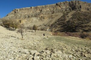
This archaeologist added: This area includes several narrow anticlines and transects parallel to each other in the north-east and south-west directions with deep valleys. Anticlines are mainly in the form of elevations that have been crushed along the axis due to high tectonic pressures and lost due to erosion. The catchment area of the Bashar River is very high and mountainous. The cross-section of the Bashar River valley is V-shaped in places where it passes through complex formations and U-shaped in areas with softer formations.
Sepidnameh stated: In the historical and Islamic era, this mountainous region, in addition to the suitable environmental conditions for the pastoral and nomadic communities of the Kohgiluyeh tribes, was able to play an essential role as an economic-cultural communication corridor due to its unique geographical location.
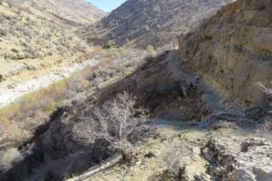
The head of the Bashar River archeology team said that despite limitations such as covering some sites with oak leaves, flood sediments, and debris on the slopes of the heights on both sides of the Bashar River, 17 ancient sites from the Middle Paleolithic era to the late Islamic centuries were identified and investigated, mainly in the outskirts of Bashar River, i.e., between Teng Sorkh and Qalat village.
The identified sites include a paleolithic site, the Parthian-Sasanian periods, the first centuries of the Islamic era, and the later centuries. The identified works include a paleolithic site, a historical road, three historical cemeteries, a castle, eight nomadic sites from the late Islamic centuries, and two historical sites with an area of about two hectares.
This archaeologist added: Before conducting the archaeological investigation, it was presumed that we would witness abundance of archeological evidence from all periods, from prehistoric to the Islamic centuries in Bashar River basin because this area has all the biological conditions for formation of human settlements, considering the importance of each of its vital elements. Nevertheless, archeological evidence in several sites that have been identified is mainly from the Parthian and Sassanid periods and the first centuries of the Islamic era.
Sepidnameh said: Archaeological evidence shows that the terraces of the upper basin of the Bashar River were inhabited in the Parthian-Sasanian periods as well as the early centuries of the Islamic era. Evidence of cultures of other periods up to the late Islamic centuries is not visible. Of course, older settlements may have been buried under the sediments, washes, and ravines of the highlands on both sides of the Bashar River.
Earlier, Mustafa Deh Pahlavan, head of the cultural heritage and tourism research institute, had said at the conference “Archeological researches of Kanisib dam in the Small Zab River basin, northwest Iran”, about the importance of archeological excavations in river basins, with the warning that construction of dams has threatened more than 50% of the cultural heritage of this land, and added: ” Man chose a place to live where access to water sources is more accessible. The concentration of prehistoric, historical, and Islamic era ancient sites is in places next to these tributaries in the far reaches of Khuzestan and different parts of Iran, and the area that is considered for the construction of the dam is precisely in these places, and this means a part of it equivalent of more than 50% of our cultural heritage is threatened and will be threatened.