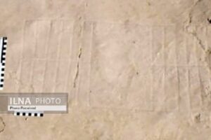
After 45 years, the mystery of the seal of a Sasanian stone inscription above Naqsh-e Rostam in Marvdasht was revealed by researchers.
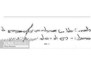
The transliteration of the stone inscription is as follows: “The Lamb Valley / raising goats, like twelve pastures; according to the writing of the Kam section, then to that Chineh Mountain / a few Kams to seep through the work of the fence.”
According to Ilna, the location of Naqsh-e Rostam in Marvdasht has long been the focus of the Anshani (Elamite), Achaemenid, and Sassanid kings, who each created their tombs or tombs in the heart of Naqsh Rostam rocks, six kilometers north of Persepolis in Fars province. The proximity of this place to the city of Estakhar, which is the birthplace of the Sassanid emperors, made the Nakhsh Rostam Mountain full of monuments, which later historians and geographers of the first Islamic centuries called “Naqshat Mountain” and foreign tourists called it “The Graveyard of Gabrs (magus)”.
A strong fortress above the reliefs of Naqsh-e Rostam and a thick defense wall, 4 meters wide and 1500 meters long, was still standing for several centuries after the attack of the Muslim Arabs, until during the Daylam era, many residents of the city of Estakhr and the castle of Naqsh-e Rostam moved to the city of Shiraz. After that, this place was gradually deserted.
In the process of discovering and examining historical stone inscriptions, this time Abolhasan Atabaki, a scholar of ancient languages and a doctorate in history, announced the reading of another stone inscription that was rediscovered after 45 years and for the first time in collaboration with Najmeh Ebrahimi, a senior expert in history, and Fazlollah Habibi, a doctoral student in archaeology, was reviewed, read, and published in “Avaye Tarikh” magazine in Tehran.
In the process of discovering and examining historical stone inscriptions Wolfram Kleiss, and he made a copy of it available to Professor Seyfoddin Najmabadi. After seeing and examining this inscription, the late Najmabadi wrote a 2-page report on it and presented it to the “Congress of Art and Archeology”, in Berlin, in 1979 AD, which said: due to the destruction of the stone inscription and loss of words, he has not been able to read it.
Atabaki said: “Since the late Najmabadi did not succeed to read this stone inscription, we put all our efforts on it and were finally able to read this stone inscription, in order to open the way, if even a little, for future researchers.
In this regard, the researcher said: “This inscription is the most important one we encountered in our past investigations. One of the biggest petroglyphs written in the dimensions of 10 X 75 cm, and unfortunately, since it was exposed to the open air, the rainwater homogenized many limestone sediments in it, and this caused the deposits to form a layer.”
He continued: “Since long ago the natives called the southern valley of Naqsh-e Rostam (which has tombs carved out in it) “lamb valley” and since this inscription is also located in a valley in a mountain in the eastern part of the mountain range, we found out, by reading the inscription, that his valley was called “Goat Valley” in the Sassanid period. This shows that the present name “Lamb Valley” has a history from the Sassanid period, which has remained in the memory of the natives.
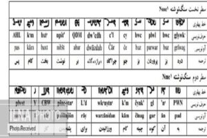
According to Atabaki, a honeycomb-like table has been carved next to the stone inscription. It is depicted in two 12-sections. We think that in those days the shepherds of Naqsh-e rostam fortress divided this mountain into 12 sections for grazing pastures for their livestock. Another reason for this table-like design is in connection with the structure that the residents of Naqsh-e Rostam fortress used as the “Saroj Dam” to use drinking water and water needed by their cattle.
He said: This “saroj dam” (dam built of cement and mortar) is one of the oldest water structures built on top of the mountain range in a “broken form.” The length of this dam is nearly 36 meters, and the width is almost 8 meters at the base end. Its height is over 4 meters, and its upper parts have been destroyed over time.
Atabaki added: In the eastern rock of the same mountain valley, we came across “twelve horizontal semi-circles” three meters high, carved into the rock, and its use is unclear. The future excavations that will take place next to this Saroj dam will reveal the secret. These carvings are in the heart of the rock.
This dam, which is made of broken stones and mortar, and the inscription as mentioned earlier was written because of it, was originally a “dam” or a dam with a “broken design” that provided the accumulation of water for the residents of Naqsh-e Rostam Fort and their livestock. The water storage method was such that they directed part of the water from the dam to numerous watering holes for their livestock and provided part of their herds’ water needs in the year’s hot seasons. In addition, after damming the rainwater from the floods for the drinking water of the residents of Naqsh-e Rostam fortress, they poured it into large tanks. After accumulating it, they used in times of need. If the example of this type of structure, although in the form of an earthen dam in “Shekasteh (broken) Castle” and “Estakhar Castle” from “Se Gonbadeh (three-domed) Castles,” has been examined before, and it was used to accumulate drinking water with the same method.